HACKETT’S GULLY
Hackett’s Gully is a suburb within the Shire of Kalamunda and is mainly bushland. It is crossed by the creek also called Hackett’s Gully which in turn flows into the Piesse Brook.
Very few roads are within Hackett’s Gully the main ones being Bahen Road and Mundaring Weir Road along which there is housing and orchard activity. Gunjin Road or track leads to Mount Gunjin, the site of what used to be a fire lookout tower. Mountain biking is a popular activity in the area around Mount Gunjin.
History
It was thought that Hackett’s Gully was named for Thomas Hackett (1810 to 1866) who reputedly developed a market garden along the creek. This is unlikely.
It is more likely to be named for John Winthrop Hackett, journalist, who was paying rates in 1906 on a Vacant 10 acre block (Location 170) which is in that area. J.W.Hackett was a very influential man, a proprietor of the West Australian Newspaper and later the rural-focused Western Mail. During the crucial period in West Australian history from the 1880s until his death in 1916, Hackett with Premier John Forrest and Anglican Bishop Riley, influenced many of the decisions to do with the impacts of the 1890s goldrushes, the establishment of the system of self-government after 1890 and the entry into the Federation. He is perhaps best remembered as the first Chancellor of the University of Western Australia.
Attractions
Munda Biddi Cycle Track
A section of the Munda Biddi Cycle Track passes through Hackett’s Gully. The Munda Biddi Trail (which means path through the forest in the Noongar Aboriginal language) is fast becoming a world-class nature-based off-road cycling experience. The Trail officially starts in Mundaring and meanders 1000km through scenic river valleys and the magnificent eucalypt forests of Western Australia’s South West, finishing in Albany. For more information, go to
Beelu National Park
Formerly known as Mundaring National Park, Beelu National Park is situated to the west of Mundaring Weir Road in the Shires of Mundaring and Kalamunda. This beautiful 3000-hectare park includes the popular recreation sites of Fred Jacoby Park, South Ledge, North Ledge, Farrell Grove, The Dell, Gungin Gully, Pimelia Mycumbene and Grevillea Mycumbene. The Park was renamed in 2008 as an acknowledgement of the traditional owners of the area. The word Beelu is derived from the Noongar word for river or stream. The Beelu people were the original peoples of the area whose district was bounded by the Helena, Swan and Canning Rivers. The Park contains a variety of native flora including Jarrah, Marri, Zamia, Bull Banksia, Sheoak and Grass Tree. In terms of facilities, Beelu National Park has toilets, wood barbecues, picnic tables and a good selection of hiking and mountain bike trails. An information centre, the Perth Hills National Parks Centre (Allen Road, Mundaring – just off the Mundaring Weir Road) is located within the park and is open between 10.00am and 4.00pm to offer advice and refreshments to visitors. Two campsites are available to use within the park.
[Historical images for community profiles are contributed by The Kalamunda Historical Society]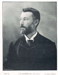
A.W. HACKETT