WATTLE GROVE
Wattle Grove is located in the foothills / plains region of the Shire of Kalamunda. It is a semi rural area with some urban development. It sits on the outskirts of the Shire and is adjacent to Forrestfield and Lesmurdie.
Wattle Grove has no major retail facilities within its boundaries, has two vets, a motel, a number of nurseries, landscape suppliers, agistment paddocks, boarding kennels and a Bird / Fish & Reptile shop. Hartfield Recreation Centre is located nearby. Wattle Grove is served by Wattle Grove Primary School, and a Community TAFE Centre in Lewis Road and the Bible College of Western Australia (Grace Community College). Other major features include Tomah Swamp and Camp Wattle Grove. The total population for the suburb of Wattle Grove is approximately 4,300.
History
Wattle Grove has a very varied history : it has straddled the moving boundaries of the Darling Range Road Board (now called the Shire of Kalamunda) and also the Queens Park Municipality (now called City of Canning). Parts of what were Wattle Grove are now called Queens Park. Wattle Grove as we know it now is within the Shire of Kalamunda.
At the time of the European settlement of the Swan River Colony, the local indigenous people of the foothills were the Beeloo with a young leader named Munday. The sandy foothills area was the site of many paths criss-crossing and travel was easy. A scarred tree is still preserved indicating Aboriginal activity.
In the later 1800s Alexander Forrest, brother of John Forrest, received a large grant in the area and he used it for pastoral activity. Also, from 1905 to 1910, there was a large encampment area for displaced Aboriginal people. Called Maamba, it was overseen by Mr George Prinsep. The self-styled anthropologist, Daisy Bates, spent much time there with the aboriginal inhabitants.
Canning historian Charles J. McIntosh, says that by 1900 the whole area was known as Wattle Grove because of the prolific yellow – flowering wattle bushes and the low-lying nature of the land. Also in the early 1900s, Mr Brittain took up 70 acres of land from Alexander Forrest near Wharf Street and he called his farm Wattle Grove Farm. Mr Charles Hale, for whom Hale Road is named, arrived in the district in 1902.
By 1911, the Welshpool Road had been formed through the bush (it was not sealed until 1938) and this enabled a land subdivision called Wattle Brook Estate to be auctioned on 5th August 1911, with lots of 10 to 27 acres. From then on, Wattle Grove was on the move.From these very early years, despite the sparse population, there was a dynamic community.
In 1912 Mr Sidney Marriott, a land agent, and others like Charles Hale founded the Wattle Grove Progress Association and immediately started lobbying the government for a community hall and school. Marriott supplied a suitable block of land, the Certificate of Title being vested in himself but also local orchardists, Charles Hale and John Reynolds. The plans for the combined school and hall were drawn up by the enterprising Marriott and were built largely by volunteer labour using local Jarrah timber cut from Mr Schofield’s property. A grand opening occurred in 1914, a year before the Education Department was ready to supply a teacher. But now the community had a centre, albeit unlined, very cold and on land that was subject to flooding.
Researchers, Joyce Taylor and Eileen Philips, writing in the Echo Newspaper (20thJune 1998 p.20), reminisce how proudly the local people cooperated to enjoy life. On 15th April 1915 ( coincidentally just days before the disaster at Gallipoli), a Grand Sports Day was held on the newly cleared land at the rear of the Wattle Grove Hall. The dignitaries were joined by about 400 people to have fun. The twelve event program included a married women’s50 yard open handicap race. First prize for the race was a 50lb bag of flour, second prize a pair of ducks and third prize an ox tongue!
The foothills suburbs, although sandy, had a generally good water supply from the Woodlupine Brook, the Yule Brook, as well as good ground water. Many primary industries were commenced from fruit growing (plus some grain), poultry farming, dairy farming, nursery flowers and many others.
Following the end of World War One, many new settlers arrived to take up land including the Taylor family and the Archer family on Lewis Road in 1926. Other arrivals during this period include the Davies, Peters, Fennells, Bassetts, Daddows and Cross family.
In 1931 an Athletic Club was formed and run by Fred Taylor until he and many other locals left for World War Two.
In 1933 Mr Max Wells and his family took up a property on Gavour Road and held church services in the little hall. It was soon decided to build a Wattle Grove Baptist Church which commenced in 1938. Even the cement bricks were made by volunteer weekend labour. This venture was also interrupted by the war but activity resumed in 1946. The church was opened in 1947 amid much celebration.
In 1939 a new brick school had been built in Welshpool Road and served local children until 2011 when a new school was built in what is a large new housing estate which is growing rapidly along the eastern side of Welshpool Road in the place of former paddocks.
In 2012 Wattle Grove along with the adjacent Forrestfield forms part of the most dynamic and fast-growing areas of the Shire of Kalamunda. Planning for an enhanced shopping centre and a large new community hub is well under way.
Further information and photographs of Wattle Grove can be found in the Kalamunda Library’s Local Studies Room. For assistance, ask staff.
Also see the Foothills Connection Community Heritage Project
[Historical images for community profiles are contributed by The Kalamunda Historical Society]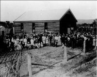
Wattle Grove Hall 1914
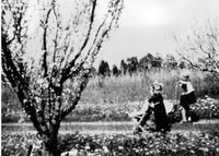
Crystal Brook Rd property
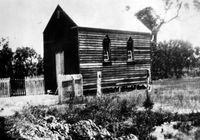
Congrgrational Church 1916